Forum Replies Created

Page 7 of 14
  • Tom Morton

    December 14, 2023 at 7:09 am in reply to: Map coordinates pulled from excel?

    No problem Adam, what goes around comes around so more than happy to help 🙂

  • Tom Morton

    December 13, 2023 at 3:49 pm in reply to: Map coordinates pulled from excel?

    Hey Adam, no worries, it’s not always straightforward. Well not sure what it is but when I changed mine to the wrong filename, I got an error saying it couldn’t find that footage. Your error is different so I’m guessing it might be to do with how your CSV is structured.

    Try opening up the CSV file in a notepad, just check each row is on a separate line and that the values are comma separated. How many columns of data do you have by the way? – it’s possible that one of the values somewhere is causing a problem when it’s trying to parse the file.

    To help you troubleshoot it, add a blank text layer in your comp. Then on the source text property, Alt + click on the stopwatch and try a few different bits of code here, this might help you work out where the problem is occuring. First try:

    value = footage(“afxtest.csv”);

    This should show the whole document, it will probably overflow the text box but that just shows it’s working. Then if that works, try:

    value = footage(“afxtest.csv”).sourceText.split(“\r”);

    Does this work ok? If so, try adding “[0]” before the semicolon at the end to just return the first row. If this causes a problem, you could try “\n” instead of “\r” = they mean similar things but one may work and other may not. Then try:

    value = footage(“afxtest.csv”).sourceText.split(“\r”)[0].split(/,/);

    Does this work? Again, try adding “[0]” before the last semicolon to return the first value of that row. Possible that there is a comma within a single value (ie, “This, Location” which may cause an issue when parsing.

    Give this a go and work out where the problem occurs. You might be able to figure it out yourself from there, but feel free to post back if not. It’s possible to add lots of code to deal with any errors but it may also help to simplify the CSV file – remove any extra columns, remove commas from any text etc.

  • Tom Morton

    December 12, 2023 at 4:37 pm in reply to: Map coordinates pulled from excel?

    I’m just going to dash a quick step by step from out of my head in case you’re still struggling. Any problems, let me know and I’ll try and clarify later.

    1. Create your project / comp.

    2. Ensure each value you want to use is in a separate column in the CSV file.

    3. Drag the CSV file into the project panel

    4. Create the design of the marker you want to use for the pin on the map (pin, dot, star etc) and add this into your comp (make sure it’s a single layer)

    5. Open the transform properties for this marker and Alt + click on the stopwatch next to “Position”. This opens the expressions panel for the Position property.

    6. Paste in my code above in the expressions panel.

    7. Rename the “afxtest.csv” file in the code to be the same name as your CSV you imported.

    8. Now, the position of the marker layer should be adjusted to match the first coordinates on the CSV file.

    9. Duplicate the marker layer. Every time you duplicate it, each layer should automatically pick the next row in the CSV file and adjust the position accordingly.

    10. Keep duplicating 🙂 Hopefully this will work!

  • Tom Morton

    December 12, 2023 at 4:29 pm in reply to: Map coordinates pulled from excel?

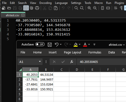
    Ah yes, there is a slight issue there. The latitude and longitude variables get the first and second cell of each row, but in your example both coordinates are in the same cell. You might be best off using the excel split function to split this column into 2 columns using the comma as a delimeter.

    I’ve added a screenshot of the afxtest.csv with it open in excel and Notepad++.

  • Agree with this, there are no real standards because it’s a creative process – it’s all subjective and usually down to the editor. Editing for TV / broadcast is a totally different ball game with very specific standards. As far as I’ve seen, most editing studios that are creating videos for companies to put on social, youtube and so on will generally edit to these settings:

    1920p or 4K resolution

    Aspect ratio of 16:9

    Rec.709 color space

    H264 in a .mp4 container

    Bitrate of at least 20Mbps.

    These are the most common settings we work to, and the most common that I’ve seen – it’s what we use for probably 95% of our projects. But yes, can’t stress enough that it’s a creative process and all these things can vary depending on the clients wants and the end goal.

  • Tom Morton

    December 11, 2023 at 4:51 pm in reply to: Map coordinates pulled from excel?

    On my project, I just quickly tied those variables to expression controls, which made it really easy to fine tune the stars to match the points on your map. Hope I helped!

  • Tom Morton

    December 11, 2023 at 4:41 pm in reply to: Map coordinates pulled from excel?

    Boom, just had a look at this and it was easier than I thought. Save the excel sheet as a CSV file, and then drag in that CSV straight into the project panel of your After Effects Project (don’t add it into your comp). Then, create a marker in any style you want, and paste in this code into the expressions field of the “Position” property:

    —————————————————————————————-

    // get the coordinates from the CSV file in the project panel

    pos = footage(“afxtest.csv”).sourceText.split(“\r”)[index-1].split(/,/); // “index” get current layer number so for each duplicated layer this will +1

    latitude = pos[0];

    longitude = pos[1];

    // need to map lat and long to pixel position

    highestPoint = 90; // the highest point of latitude shown on map: corresponds to 0 on the Y axis

    lowestPoint = -90; // the lowest point of latitude shown on map: corresponds to the canvasYsize on the Y axis

    leftmostPoint = -170; // the point furthest to the left in longitude: corresponds to 0 on the X axis

    rightmostPoint = 185; // the point furthest to the left in longitude: corresponds to the canvasXsize on the X axis

    // size of your comp so we can map the coordinates to pixels

    canvasYsize = 1080;

    canvasXsize = 1920;

    // calculate the position of the X point

    xRange = rightmostPoint – leftmostPoint;

    trueX = longitude – leftmostPoint;

    xPos = canvasXsize * (trueX / xRange);

    // calculate the position of the Y point

    yRange = highestPoint – lowestPoint;

    trueY = latitude – lowestPoint;

    yPos = canvasYsize – (canvasYsize * (trueY / yRange));

    // boom

    [xPos, yPos]

    —————————————————————————————-

    On the second line, rename “afxtest.csv” as the name of the CSV file in your project panel.

    This code will reposition the centre of the marker to be roughly at the latitude and longitude of the points on the map. Every time you duplicate this layer, the duplicate layer will read from the next line of the CSV file and change the position of the marker.

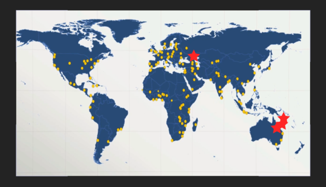
    I’ve done this very quickly and used a screenshot of your map as a base, and used red stars as markers. See the attached screenshot.

    For fine tuning, you can adjust thse variables: “highestPoint”, “lowestPoint”, “leftmostPoint”, “rightmostPoint” and it will adjust the position to your map. You may want to test it out, get them right and then duplicate the layers. Otherwise, tie these variables into control sliders so you can duplicate them all and adjust them all at once.

  • Tom Morton

    December 11, 2023 at 8:39 am in reply to: Map coordinates pulled from excel?

    I think it should be possible to use an expression to map a range of dots to the location on the map. Can you give some examples of locations from your excel document to see what data we’re working with?

  • Tom Morton

    December 8, 2023 at 3:12 pm in reply to: Can’t Install 22 version of Premiere!!

    As Rob says, Premiere Pro is definitely past it’s prime and generally, editors are moving to Resolve now. That said, I may be able to help…

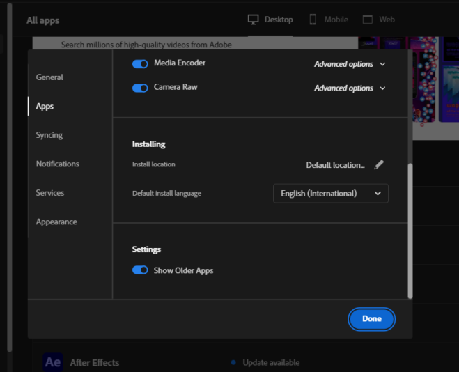
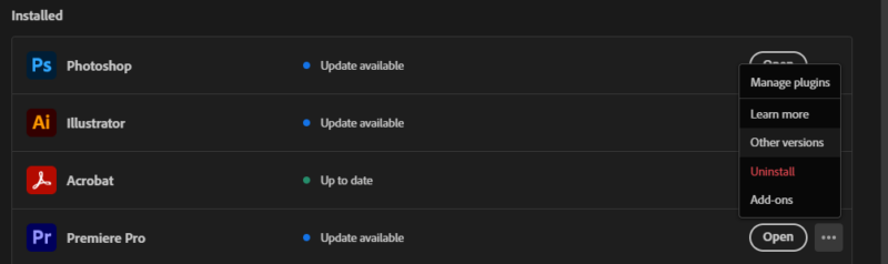
    Open your Creative Cloud app, click on your profile image and open “Preferences”. On the “Apps” section, scroll to the bottom and turn on “Show Older Apps”.

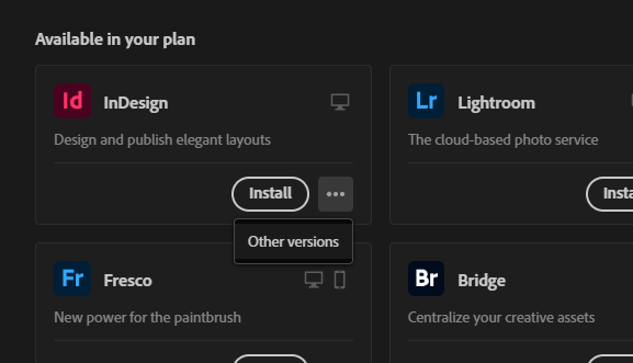
    Now, go find Premiere Pro in the list of apps and click on the 3 dots, you’ll get an option for “Other versions”.

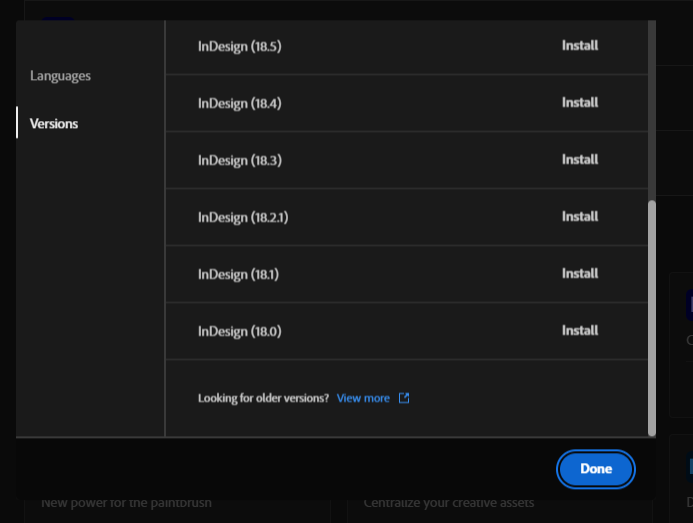
    There you’ll get a list of versions available to install. At the bottom of this list, you’ll now see a link to “Older versions” which takes you to a webpage where you can find all the previous versions for install.

    I’ve shown this on Indesign but it’s the same for all apps. Hope that helps!

  • Tom Morton

    December 8, 2023 at 7:29 am in reply to: Custom distortion of profile of sweep object

    But it sounds like you want to animate the sweep, so if you make the ribbon editable, that’s going to be more tricky. I think if you duplicate the sweep, make one editable and add the deformers to it. Then you can animate the duplicated sweep, drop them both into a boole and the animation will hide the editable sweep.

Page 7 of 14

We use anonymous cookies to give you the best experience we can.
Our Privacy policy | GDPR Policy